

From model access to planned analysis
Google first introduced Earth AI as a suite of models for remote sensing, weather, flood hydrology and population dynamics. Its early Gemini-based prototype connected those models to answer questions that required more than one kind of data. The new system adds planning: it lays out steps, selects tools and datasets, and can process large map layers outside its context window.
The agent can draw on WeatherNext, Flood Forecasting, Population Dynamics Foundation Model, AlphaEarth Foundations and Remote Sensing Foundations, alongside Google Maps Platform, Earth Engine, Data Commons and Google Dataset Search. Organizations can also provide their own data, including CSV tables, GeoJSON boundaries and cloud tables.
For forecasting, users can supply local outcome data—such as disease rates, crop yields or power outages. The agent then selects relevant population and environmental indicators, combines Population Dynamics Insights with Custom Satellite embeddings, and trains machine-learning models for spatial forecasting, downscaling and predicting future change.
In a recent public-health study, Google says combining demographic and satellite data improved health-outcome forecasts by 12% over demographic baselines and enabled maps at 8 times higher spatial resolution. That result is promising, but it describes one study, not a general performance guarantee for the agent.
Source: research.google
A user request becomes a plan, a sequence of selected Earth AI tools and datasets, and a report with text, tables and maps. Google says the agent shows its plan and data sources so specialists can check assumptions or substitute datasets.
What the benchmarks measure
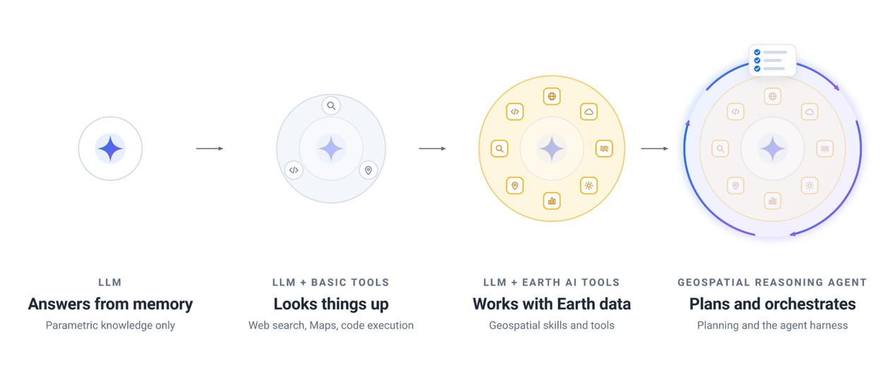
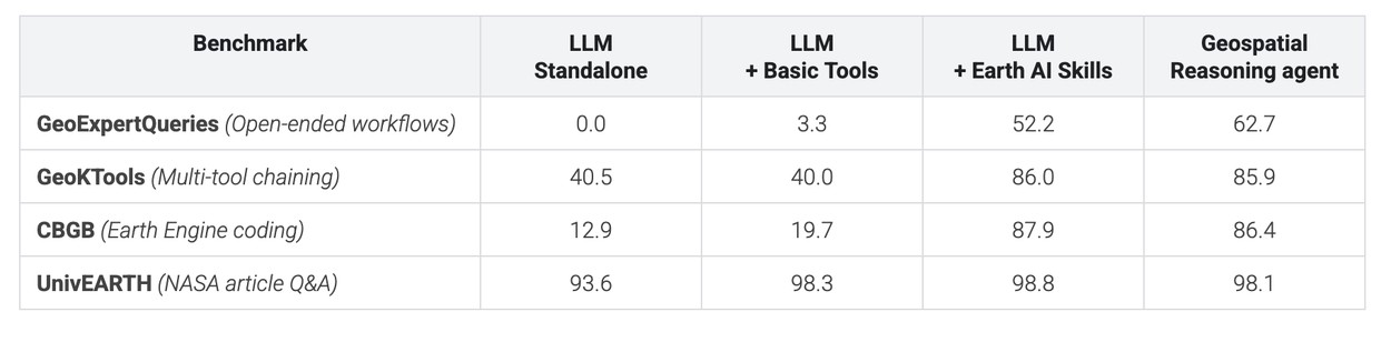
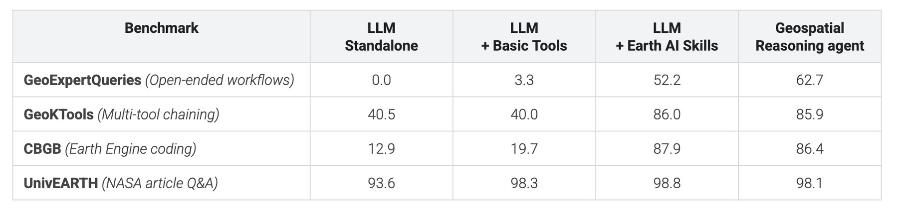
Google compared four configurations, from a language model without extra tools to the full agent with a separate planning stage. The evaluation used Gemini 3.8 Flash and Gemini 3.1 Pro, and covered four benchmarks: two external tests for geospatial code generation and question answering, plus two new benchmarks built for multi-step work.
Google is releasing the full training sets for both new benchmarks. The company says Earth AI tools improved results on GeoExpertQueries, GeoKTools and CBGB compared with basic search, map-grounding and code-execution tools. On UnivEARTH, however, even a standard language model scored 93.6%; Google suggests the benchmark’s source material and answers are readily available online.
Source: research.google
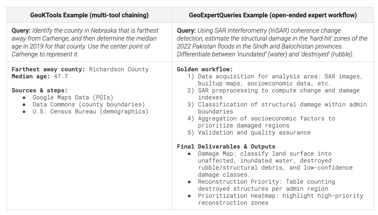
The two new tests probe different capabilities: GeoKTools focuses on selecting and applying specific tools, while GeoExpertQueries evaluates open-ended, multi-step workflows.
Source: research.google
The results also suggest that tools alone are not enough. Earth AI skills helped on narrower tests, but the more open-ended GeoExpertQueries benchmark benefited from advance planning. Google says planning reduced unreliable assumptions and shortcuts, such as substituting web search for spatial analysis.
There is an important limit to that evidence: GeoExpertQueries uses an automated system to compare an agent’s work with expert plans. It does not verify whether the final answer is correct. Google describes the output as a first draft for experts to review and improve.
Field tests are the stronger case
Google gave a small group of commercial and social-impact organizations early access. Their examples show where the agent may save time, though they are partner-reported cases rather than an independent evaluation.
Source: research.google
Google says partner testing also drove improvements, including road-network routing, support for larger user datasets and better discovery of authoritative local sources.
Source: research.google
I think the most consequential question is not whether the agent can produce a map quickly; the examples suggest it can. It is how often a fast, plausible analysis survives expert review, especially when the benchmark itself checks workflow rather than answer accuracy. The Ebola example is compelling, but the announcement does not provide a measured error rate or a comparison of the agent’s recommendations with what field teams ultimately verified.
Access remains limited
Google is expanding access through two routes:
Planetary Prediction Engine is also available in preview, through an interactive interface or the agent API. Access is limited for now.
The product’s value will depend on whether organizations can move from a persuasive first-pass map to a result they can safely act on. Google is building the review step into the story; the open question is whether the system can make that step smaller without making it less necessary.
Daily AI news
Every day we pick what actually matters in AI and explain it plainly — no hype, no filler. Subscribe if you want to follow where the industry is going.
Only what matters — every day
Follow on X