

Google Research has introduced ME-POIs, a method that mixes aggregated, anonymized movement data into the embeddings language models build for physical places. On places the model had never seen during training, the addition produced relative gains of up to 81.9% in predicting intent to visit, 75.1% in classifying price level and 24.7% in estimating busyness. The work involved Neha Arora of Google Research together with professor Cyrus Shahabi and PhD student Shang Ling Hsu at the University of Southern California.
The conceptual move matters more than the percentages. Earlier geographic research used mobility data almost exclusively as a prediction target: given where a person has been, guess the next point of interest they will visit. ME-POIs turns that around and makes mobility an input feature — part of how the place itself is defined. A point of interest, in this framing, has two separate properties: its identity, meaning the name and the category on the sign, and its function, meaning the aggregate trace of how people actually use it.
Language models normally build representations of businesses, parks and landmarks from static material — addresses, business categories, text descriptions. Even a model like Gemini, strong on text, gets a thinner picture of a place than the place supports. Arrival windows, dwell times and the movement around a building carry the daily and weekly rhythm that no description contains.
The pipeline has three stages: aligning visits, propagating them spatially across several scales, and fusing the result with text. For the first, the system treats aggregated visits to a specific building as base data, reading arrival windows, departure trends and typical dwell length. Rather than averaging them, a temporal encoder maps those sequences into a dense vector space, producing what the researchers call a functional center — a multidimensional fingerprint of the anonymized movement tied to a place across a yearly cycle and across days of the week.
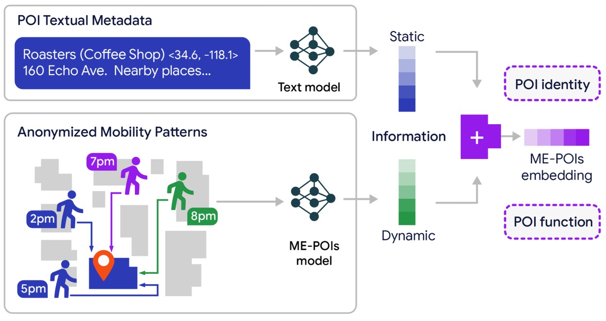
A diagram showing how textual POI metadata and anonymized mobility patterns combine into a ME-POIs embedding
Source: research.google
The second stage exists because geographic data has a long tail. Landmarks, large malls and popular chains accumulate visit data; most local businesses — small shops, specialist workshops, cafes that opened last month — do not. A model reading a sparse record has previously been liable to treat a place with few entries as a place with no activity, and predict accordingly. ME-POIs handles this by propagating visit patterns spatially, on the assumption that visits belong to a district as much as to an address: a small boutique on an expensive retail street shares behavioral traits with its neighbours. The system reads nearby places at street, block and wider-district level, then statistically transfers the aggregated patterns of data-rich neighbours to data-poor ones, forming a regional prior it can apply to a shop that barely appears in the data or does not appear at all.
The third stage keeps the text. High-level language embeddings of the kind produced by Gemini are aligned with the mobility vectors by maximizing cosine similarity, so the movement signal is added to the language representation rather than replacing it. The hybrid keeps the semantic structure — the model still knows the business sells food — and gains the operational context that tells a lunch spot from a place that runs late.
To test whether any of this generalizes, the researchers ran it across two large and culturally different metropolitan areas, Los Angeles and Houston, on five tasks: opening hours, permanent closure, intent to visit, peak busyness and price level. The model was trained on known locations and then asked to predict properties of entirely new ones. Baselines included text-only embeddings such as Gemini's, existing trajectory-based geographic models such as TrajGPT, and hybrid variants, which isolates what the mobility contributes.
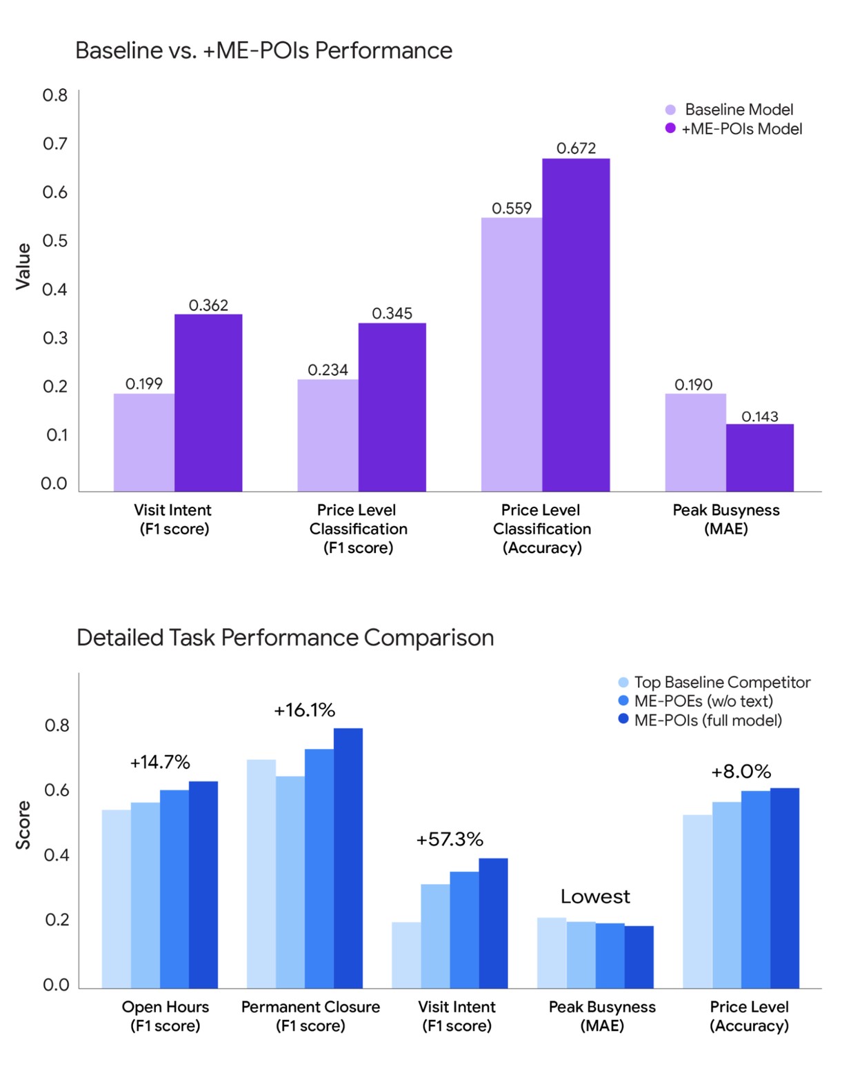
Two bar charts showing that the ME-POIs model outperforms baseline models across different prediction tasks
Source: research.google
ME-POIs beat the text-only and mobility-only baselines on every task tested, with the widest margins on visit intent and price level.
The result most worth pulling out of that comparison is the one the write-up treats as a footnote. A model trained on mobility alone outperformed the text-based language models on some tasks, price-level classification among them. Read plainly, that says the crowd's behavior at a location describes it more accurately than the words on the sign or in the directory listing. For an industry that has spent three years assuming text is the universal substrate for world knowledge, that is a sharper claim than an 81.9% relative gain.
The percentages themselves deserve more caution than they usually get. All three are relative improvements over a baseline whose absolute performance is not stated, and a large relative gain on a task the baseline was bad at is a smaller achievement than the same gain on a task it was decent at. The generalization claim is also narrower than it sounds: unseen places, yes, but inside two American metros the model was trained on. Whether the learned regional rhythm survives a move to a city with different working hours, different retail density and different transport has not been shown here.
The quieter question is provenance. The paper's position on privacy is clear and consistent — the system models buildings, not people; it draws no conclusions about individual users and is not built for personalization. That is a property of the output. The input is still a year of arrivals, dwell times and departures around essentially every business in two major cities, and the write-up says nothing about who else could assemble such a thing, or on what terms.
That asymmetry is the real result. If a place's embedding already encodes its rhythm, then "what is this business" and "how busy is it on a Tuesday evening" collapse into a single cheap lookup for whatever model comes next — and ME-POIs is now part of Google Earth AI, the company's broader push to turn planetary data into usable geographic models. The organizations that can build these fingerprints are the ones already holding metro-scale movement data, which is a much shorter list than the one of organizations that would like to reason about physical places.